The Overmountain Victory Trail: Exploring a Revolutionary War Story in Western North Carolina


As America celebrates its 250th anniversary, there is no better time to step outside and experience one of North Carolina’s most compelling Revolutionary War stories.
Winding through some of the most beautiful landscapes in the state, the Overmountain Victory National Historic Trail connects history, outdoor recreation, and the communities that helped shape the story of America. For visitors exploring Western North Carolina, the trail offers a unique opportunity to walk, hike, bike, and drive along portions of the route traveled by Patriot militia in 1780 on their way to the pivotal Battle of Kings Mountain.
The Overmountain Victory National Historic Trail stretches approximately 330 miles across Virginia, Tennessee, North Carolina, and South Carolina, with roughly 225 miles of the route located in North Carolina. Today, the historic corridor is becoming an increasingly important part of North Carolina’s outdoor recreation landscape.
And right here in Rutherford County, visitors can experience several accessible trail segments that bring that history closer to home.
A Revolutionary War Story: The “Turn of the Tide”

In October 1780, Patriot militia from across the region gathered and traveled toward Kings Mountain. Their journey brought together ordinary citizens who answered the call during one of the most critical moments of the Revolutionary War.
Their victory at Kings Mountain became a significant turning point in the Southern Campaign. Thomas Jefferson later described the battle as “the turn of the tide of success” in the Revolutionary War.
Nearly 250 years later, the route remains a reminder of the people who traveled these roads, crossed these mountains, and helped change the course of American history.
The Overmountain Victory Trail was designated a National Historic Trail in 1980, becoming the first National Historic Trail established in the eastern United States. North Carolina later designated it the Overmountain Victory State Trail in 2019, creating new opportunities to preserve the route while connecting communities and expanding recreational access.
Today, historians, volunteers, trail organizations, local governments, and state and federal agencies continue working together to protect and promote this important piece of American history.
History Meets the Outdoors
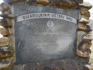
One of the most fascinating things about the Overmountain Victory Trail is that you don't have to be a history buff to enjoy it.
The trail connects historic landscapes with modern outdoor experiences. Portions of the route overlap or connect with greenways, hiking trails, shared-use paths, and other major trail systems throughout Western North Carolina.
That means a visit can look different for everyone.
You might spend the morning learning about the Overmountain Men and Revolutionary War history, take an afternoon hike through the foothills, ride a paved greenway, or simply follow the Commemorative Motor Route through the communities and landscapes that tell the story.
As America celebrates 250 years, the Overmountain Victory Trail provides a meaningful way to experience the past while enjoying the places that make Western North Carolina special today.

Explore the Overmountain Victory Trail in Rutherford County
Rutherford County is home to several trail opportunities connected to the Overmountain Victory story. These accessible locations make it easy to add a little history to your next outdoor adventure.
Thermal Belt Rail Trail: Mile 3.7 to 4.7, Rutherfordton
If you're looking for an easy, paved way to experience a portion of the trail corridor, the Thermal Belt Rail Trail is a great place to begin.
This one-mile segment provides a walkable and bike-friendly experience through Rutherfordton. The paved surface makes it accessible for walkers, runners, and cyclists, while its connection to the Overmountain Victory story adds another layer to the experience.
Distance: 1 mile
Surface: Paved
Uses: Walk, run, bike
Difficulty: Easy
Whether you're out for a quick walk or exploring Rutherfordton by bike, this segment offers a simple way to connect recreation with local history.
Purple Martin Greenway: Kiwanis Park, Rutherfordton

Located at Kiwanis Park, the Purple Martin Greenway provides another opportunity to explore Rutherfordton on foot or by bike.
The approximately half-mile paved trail is easy to navigate and is ideal for a casual walk, a run, or a family bike ride.
Distance: 0.5 mile
Surface: Paved
Uses: Walk, run, bike
Difficulty: Easy
For visitors traveling through Rutherford County, this is an easy stop to add to a day of exploring local trails and historic sites.
Alexander Ford: 394 Grays Chapel Church Road, Rutherfordton
For those looking for a more natural trail experience, Alexander Ford offers a 2.2-mile loop with a natural surface.
The trail can be used for hiking and running and is rated easy, making it an inviting option for visitors who want to spend more time outdoors while exploring the Rutherford County portion of the Overmountain Victory corridor.
Distance: 2.2-mile loop
Surface: Natural
Uses: Hike, run
Difficulty: Easy
Norris Park: 156 Leroy Mill Drive, Rutherfordton
At Norris Park, visitors can explore a 1.5-mile loop on a natural surface.
This segment offers opportunities for walking and running, although the terrain becomes more challenging, with medium difficulty and some steep sections.
Distance: 1.5-mile loop
Surface: Natural
Uses: Walk, run
Difficulty: Medium/steep terrain
It's a great option for those who want to combine local history with a little more of a workout.
Discover More of Western North Carolina
Rutherfordton is just one stop along a much larger story.
Across Western North Carolina, the Overmountain Victory Trail connects visitors with places such as Lake James State Park, Morganton, Elkin, the Yadkin and Catawba River corridors, Fort Defiance near Lenoir, Roan Mountain, and Yellow Mountain Gap.
Along the way, the route intersects with some of the region's most beloved outdoor destinations and trail systems, including portions of the Mountains-to-Sea Trail and other local greenways and shared-use paths.
The result is a trail experience that can be as long or as short as you want it to be. Visitors can choose a single trail segment, plan a multi-stop road trip, or follow the Commemorative Motor Route to explore the broader Revolutionary War story.

A Trail That Connects Communities
The Overmountain Victory Trail is more than a line on a map.
It connects communities, landscapes, historic sites, parks, rivers, and people. It also demonstrates how preserving history can create new opportunities for recreation, tourism, conservation, and economic development.
In Western North Carolina, communities along the route are continuing to invest in trails and public spaces while preserving the stories that make these places unique.
That is part of what makes the trail so special. You can learn about the people who traveled this route nearly 250 years ago and then experience the same mountains, rivers, valleys, and communities that remain part of the landscape today.
Celebrate 250 Years by Exploring the Story

America's 250th anniversary is more than a milestone to commemorate. It is an invitation to learn, explore, and reflect on the stories that shaped our country.
The Overmountain Victory Trail provides a remarkable way to do just that.
You can walk a paved greenway in Rutherfordton, hike a natural-surface loop, explore a historic site, travel the scenic roads of the foothills, or venture farther along the trail through Western North Carolina.
Wherever you begin, you're following a story that started with ordinary people who came together during an extraordinary moment in American history.
This year, celebrate 250 years of America by getting outside, exploring Western North Carolina, and walking in the footsteps of the Overmountain Men.
The trail is waiting—and its story is still being told.
For those looking to discover more trails and outdoor adventures across North Carolina, Great Trails NC is an excellent resource for trail information, maps, and inspiration.


Comments